Maps: Finding Our Place in the World

What is a Map?

A collection of unusual maps from
Maps: Finding Our Place in the World


Mapping Slavery in America

Distribution of the Slave Population

Distribution of the Slave Population of the Southern States
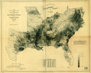
Edwin Hergesheimer, "Map Showing the Distribution of the Slave Population of the Southern States" (1861). Library of Congress.
Edwin Hergesheimer’s map of Southern slavery was printed in September of 1861 and sold to raise money for sick and wounded Union soldiers. It identified the percentage of the population enslaved in each county, and the total number of slaves—four million, up from 700,000 in 1790—was a figure that could not have gone unnoticed by Americans living through such violent upheaval. By using this relatively new “choropleth” technique of shading, Hergesheimer showed Americans their country through the lens of slavery.

The “slave map” was of particular interest to President Abraham Lincoln, as illustrated in a painting by Francis Bichnell Carpenter, First Reading of the Emancipation Proclamation of President Lincoln. [Offsite link: See an image of the painting on the U.S. Senate website.] The artist spent six months living at the White House in order to complete this work, and in that time repeatedly observed Lincoln studying the map. To master the detail on the map for his painting, Carpenter surreptitiously borrowed it; and when the president visited the artist in his White House studio a few days later he remarked, “You have appropriated my map, have you? I have been looking all around for it.” According to Carpenter, Lincoln was once again instantly absorbed by the map and used it to trace the recent progress of Union troops through Virginia. It gave Lincoln happy news, for the areas conquered by the Union just that week were densely populated with slaves. Thus Hergesheimer’s map appears in the corner of Carpenter’s painting, a detail as meticulously chosen as the artist’s arrangement of Lincoln’s cabinet: those sympathetic to emancipation appear on the president’s right, while the more conservative members are placed at his left. The map also appealed to Carpenter for its elegant organization of information. By just a glance, one could see the proportion of blacks to whites in the Southern states, which made it impossible to deny that slavery was at the heart of the rebellion.


Historical Geography

Historical Geography
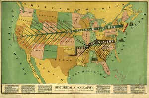
John F. Smith, "Historical Geography" (1888). Library of Congress.
The turn of the nineteenth century was a period of national reconciliation, but one that came at the cost of the rights and welfare of black Americans. Yet the Civil War continued to affect politics. The rising power of the Republican Party—born out of antislavery impulses in the 1850s—was in no small part aided by the willingness of Republicans to “wave the bloody shirt” and remind the nation of their party’s leadership during the war and unbroken Unionism. This view is embodied in the 1888 map “Historical Geography,” a vision of the nation very much at odds with the contemporary spirit of reconciliation. In this rendering the Civil War is only a symptom of a much deeper division traceable to the early days of colonial settlement and which turned on the decision to import slaves to Jamestown. From here, “history” brought forth two entirely different societies. To Plymouth came Liberty, “planted by Pilgrims upon the Bible … where it received God’s blessing” in the form of intellectual, technical, and educational advantages unblemished by the sin of slavery. By contrast, “nearly every evil which exists in the political economy of our beloved country can be traced back to the pernicious teachings of the Jamestown settlers and their children.”


Book details:

Edited by James R. Akerman and Robert W. Karrow, Jr.
Maps: Finding Our Place in the World
Foreword by John McCarter
Co-published with the Field Museum
©2007 336 pages, 198 color plates
Cloth $55.00 ISBN: 978-0-226-01075-5 (ISBN-10: 0-226-01075-9)

For information on purchasing the book—from bookstores or here online—please go to the webpage for Maps.

See also: